
GPS, find me!
How to find someone also when it seems impossible...
Imagine you are in a very busy place such as a concert, a demonstration in a square or at the Oktoberfest. How to find a friend that you lost sight of? How to revert back to the same place after going to the bathroom?
A common GPS navigation tool is designed to find fixed locations, with certain recognizable landmarks (streets and squares), but fails miserably when it comes to locate a person who is in a large open space such as a beach.
The classic navigation applications are also unable to head to a destination that is moving on its own, such as a friend who is moving.
To solve all these problems is born GPS, find me!, which, in addition to maps and satellite views provides an arrow and a distance indicator which always point to the place you need to reach, even if it is moving.
 |
 |
GPS, find me! is much more than a simple GPS application that takes you from one place to another because it offers:
- A compass.
- The ability to share your position via SMS, email, Facebook and Twitter.
- The ability to transmit live your coordinates so that you are always reachable even when you're on the move.
- A system for obtaining the coordinates with great precision through a multiple sampling.
- An address book to save the coordinates of the places you find interesting.
Introduction
GPS
To get the first fix from any GPS device may take a few seconds to several minutes. This depends on how the system works and there is no way for the application to accelerate this process.
I believe we should say a few words to clarify this concept and avoid misunderstandings on the quality of this application.
|
The GPS to work needs to know exactly the orbits of all satellites involved in the calculation of the position and this information is transmitted at regular intervals from the satellites themselves. If your device has not in memory the updated data must wait until they are transmitted and the wait can last from a few seconds up to 12 minutes. A regular use of the GPS will keep the data up to date and the wait time will be reduced to a few seconds Cases where the wait is long:
|
User manual
On installation the measurement system (meters or yards) is automatically choosen depending on the country where you are. You can change this setting at any time via the menu on the main screen.
Each button has a blue icon on the left side that when clicked opens a pop up with a small help.
The use of this application presupposes that you have some coordinates to reach. These coordinates can be entered manually, received by SMS or automatically via the Internet.
Position
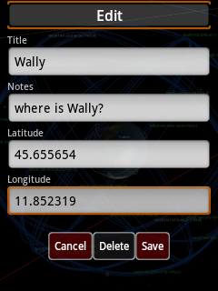
Enter a location manually
Clicking on
 |
Position by SMS
You can send your location via SMS by clicking on
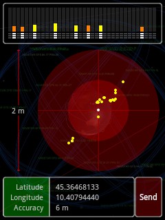 |
The panel at the top shows the visible satellites, their power, if they have downloaded the data needed to calculate the position and if they are contributing to a fix. A satellite is in use when all three indicators are white. Generally it takes three or four satellites to calculate the position and the waiting time can vary from a few seconds to a few minutes as explained here.
If you've enabled the location through the Internet you will almost immediately get a position even without waiting for the satellites, but the accuracy will be very low. If you are not satisfied with the accuracy wait until there will be a sufficient a number of satellites.
When there are enough satellites the coordinates are calculated every second and shown in the red circle in the center of the screen. On the left side the diameter of the circle is highlighted to get an idea of how the coordinates are distributed around the mean (the center).
The bottom pane displays the coordinates and their accuracy.
When you are satisfied with the accuracy press the
If you have received a text message with a location you will see it automatically in the address book. We will see later how to access it and use the coordinates.
Save current position
Of course you can also save your current location. By clicking on
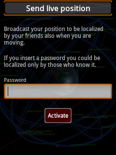
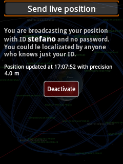
Position via Internet
If you have an Internet connection you can send at regular intervals our position so that our friends can find you also if you move.
This option is only available to registered users and can be reached via
These screens are self-explanatory.
 |
 |
Find
Clicking on
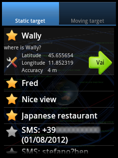 |
yellow stars refer to the items saved and gray ones are SMS which are shown as long as they are still in the inbox.
If you click on an entry it will be expanded to show further details; will appear also two clickable icons: the one on the left is used to edit, save (if it is SMS), or delete the entry, while the right one opens the screen for navigation.
The tab
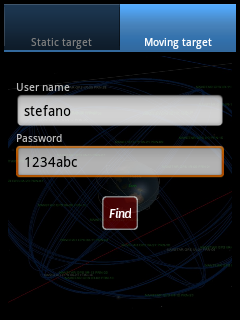 |
Enter the username and the password (if any) of any who you want to locate and
press
Navigation
These screens are accessed using the instructions described in the chapter Find.
|
|
These are the three ways that the application offers to allow you to reach your destination.
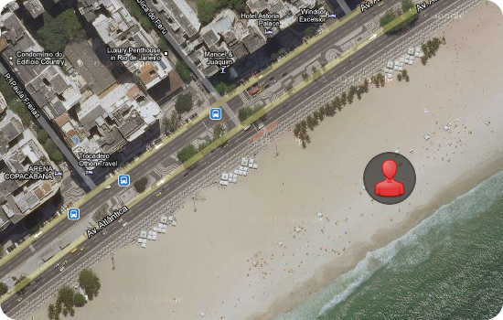
We have an arrow indicating which direction we need to go and how much we are far from the place or the person we want to achieve. This mode is valuable when we have no references on a map, for example if you are looking for a person on the beach or at a concert. For better accuracy of the arrow refer to the section calibration.
The bar with the colored LEDs that lies below the arrow indicates the precision of our coordinates (left half) and those of the destination (right half). The more LEDs turned on the less the accuracy. In the picture above is indicated a good accuracy for both.
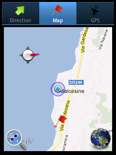
In the event that the destination is in a mapped place we have the map and the satellite view. We are highlighted with a blue circle and our destination by a red flag.
A typical case of use is to use the map to get close to the point we want to achieve and then use the arrow to reach it.
Calibration
For the proper functioning of this application it is necessary that the compass inside the smartphone is calibrated. From experience I know that this sensor is very sensitive to local changes in the magnetic field and so I recommend you to run this simple procedure every time you rely on the arrow to reach your destination.
- Open the arrow navigation page.
- When you are in an open place, at least 5 meters away from cars, computer and large metal masses, make a 8 shaped motion as shown in this video.
I personally think that the direction indicator is the best method to reach a point, however, I realize that in some devices the compass is not very precise, and this may in some rare cases extend slightly the path. I'm already working on another system that does not need compass to direct you to your destination and I'll put online very soon.